
Geography of Malta, Gozo and Comino
Malta’s location in the Mediterranean
Malta is an archipelago located in the Mediterranean Sea nearly 93km south of the Italian Island Sicily, and approximately 300km North of Libya. Even though Malta is a European island, it is located further south than some African countries such as the capital of Tunisia and Algeria. However, Malta is not Europe’s most southern point; the Greek Island of Gavdo is even more to the South.
 The Maltese Islands, how many?
There are 18 uninhabited islands forming part of the archipelago, and three inhabited - Malta, Gozo (Għawdex) and Comino (Kemmuna). Then there is Manoel Island, Filfla and the Fungus Rock which are historically and ecologically very significant. The others are mere large rocks. The Maltese islands were formed from the higher points of the land bridge that connected Sicily with North Africa. The land bridge became isolated when sea-levels rose after the last ice age, leading to the formation of the archipelago that now lies at the edge of the African tectonic plate, where it meets the Eurasian one.
The landscape of the Maltese Islands
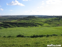
The landscape of Malta and the other islands are characterised by terraced fields, dry vegetation, rock and limestone. This is due to the long hours of strong sunshine that the Islands receive throughout the year and because there are no permanent rivers or lakes in Malta. However, there are a few waterways that supply limited fresh water throughout the year such as Lunzjata Valley in Gozo. Occasional temporary small rivers appear after times of heavy rainfall. The Maltese woods were cut down centuries ago and the only trees that survive today are the olives, ficus, citrus, pine, tamarisk and carob trees. On Malta and Gozo, hills are cultivated for both grapes and vegetables.
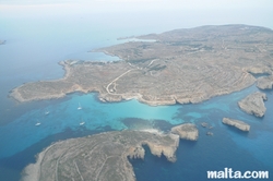
The coastline of Malta, Gozo and Comino
Just like the islands themselves, the coastline of Malta, Gozo and Comino is primarily rocky. Sandy beaches can be found mostly on the North side of the islands such as Golden Bay and Mellieha Bay in Malta, and Ramla Bay in Gozo. While the North boasts sandy beaches the south side is just the opposite, remarkably high cliffs drop straight down to the sea. The eastern side of the island is divided by three large bays, while in the West there is a concentration of natural harbours.
 Malta in brief
- Area: 316 km2
- Name: Republic of Malta (Repubblika ta' Malta)
- Population: 412,966 estimate 2010
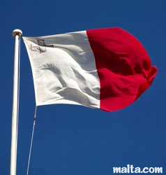
- Flag: White and red background, with the George Cross in the upper left corner of the white part.
- Capital City: Valletta
- Largest city: Birkikara, with a population of 26,000
- Coastline: 140 m
- Highest point: Ta’ Dmejrek 253m (close to Dingli)
- Official Languages: Maltese and English
- Ethnic groups: Maltese 95.3%, British 1.6%, Other 3.1%
- Demonym: Maltese
- Member of the EU: from 1st May 2004
- Time Zone: CET (UTC+1)
- Drive: on the left
- Calling code: + 356
- Currency: Euro(€)
- GDP (PPP) 2010 estimate: Total €6.95 billion
- GDP (PPP) 2010 estimate: Per capita €16,564
- Government: Parliamentary Republic, President: George Abela, Prime Minister: Lawrence Gonzi
- Independence: from the United Kingdom 21 September 1964
- Coat of Arms: Shows the flag of Malta in the form of a shield, on the top of which is a fortification with five turrets, representing all the fortifications of the island. There are two branches around the shield, and olive and a palm tree, which symbolize peace.